
Krishnarajanagara topographic map
Click on the map to display elevation.
Krishnarajanagara
Krishnarajanagara is located on the northern part of Mysore district, west of the Krishna Raja Sagara Reservoir. It has an average elevation of 786 metres above sea level. NH-373, also known as SH-57 passes through the town of K.R.Nagara.
About this map
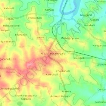
Name: Krishnarajanagara topographic map, elevation, terrain.
Average elevation: 786 m
Minimum elevation: 747 m
Maximum elevation: 833 m
Other topographic maps
Click on a map to view its topography, its elevation and its terrain.
Krishnaraja Sagara
India > Karnataka > Krishnarajanagara taluk > Yaraganahalli
Average elevation: 769 m