
Make a donation
Gear up for your next adventure:
As an Amazon Associate, this site earns from qualifying purchases at no extra cost to you.
Trembleur topographic map
Click on the map to display elevation.
Make a donation
Gear up for your next adventure:
As an Amazon Associate, this site earns from qualifying purchases at no extra cost to you.
About this map
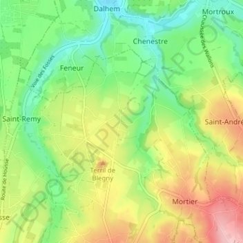
Name: Trembleur topographic map, elevation, terrain.
Location: Trembleur, Blegny, Liège, Wallonie, 4670, Belgique (50.67548 5.70662 50.71548 5.74662)
Average elevation: 150 m
Minimum elevation: 87 m
Maximum elevation: 241 m
Make a donation
Gear up for your next adventure:
As an Amazon Associate, this site earns from qualifying purchases at no extra cost to you.
Other topographic maps
Click on a map to view its topography, its elevation and its terrain.
Saive
Belgique > Liège > Liège > Blegny
Le relief est vallonné. Sur la rive gauche de la Julienne les coteaux sont dominés par le plateau de la Campagne de la Xhavée et sur la rive droite par les plateaux de Miermont, de Tignée et de Sur les Heids. L'altitude la plus haute se situe à la vôye del hayète: 225 m, la plus basse à Saivelette: 125…
Average elevation: 168 m
Make a donation
Gear up for your next adventure:
As an Amazon Associate, this site earns from qualifying purchases at no extra cost to you.
Make a donation
Gear up for your next adventure:
As an Amazon Associate, this site earns from qualifying purchases at no extra cost to you.