Geolocate

Millbrook topographic map

Click on the map to display elevation.

About this map

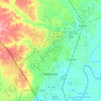
Name: Millbrook topographic map, elevation, terrain.

Location: Millbrook, Elmore County, Alabama, 36054, United States (32.44688 -86.41945 32.57045 -86.33345)

Average elevation: 82 m

Minimum elevation: 38 m

Maximum elevation: 180 m

Other topographic maps

Click on a map to view its topography, its elevation and its terrain.

Springfield

United States > Alabama > Elmore County > Millbrook

Average elevation: 95 m

Jordan

United States > Alabama > Elmore County

Average elevation: 173 m

Broadmoor

United States > Alabama > Elmore County > Millbrook

Average elevation: 71 m

Five Points

United States > Alabama > Elmore County > Millbrook

Average elevation: 61 m

Weoka Creek

United States > Alabama > Elmore County

Average elevation: 124 m

Wallsboro

United States > Alabama > Elmore County

Average elevation: 73 m

Gear up for your next adventure:

🥾Hiking Boot Waterproofing Wax - Maintain the lifespan of your leather trekking boots
🧼Technical Clothing Wash - Special soap to clean and restore waterproof membranes
🔦LED Camping Lanterns - Illumination for reading maps inside your tent at night
🌄Outdoor Binoculars - Compact binoculars for landscape observation
📱Phone Mounts for Hiking - Secure mounts to carry your phone on trails

As an Amazon Associate, this site earns from qualifying purchases at no extra cost to you.