
Ouanaminthe topographic map
Interactive map
Click on the map to display elevation.
About this map
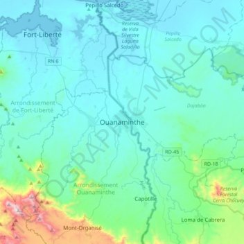
Name: Ouanaminthe topographic map, elevation, terrain.
Average elevation: 142 m
Minimum elevation: 0 m
Maximum elevation: 1,156 m
Other topographic maps
Click on a map to view its topography, its elevation and its terrain.
Caracol
Haiti > Nord-Est Department > Commune Caracol > Caracol
Caracol, Commune Caracol, Arrondissement Trou-Du-Nord, Nord-Est Department, Haiti
Average elevation: 7 m