
Marktgemeinde Fieberbrunn topographic map
Interactive map
Click on the map to display elevation.
About this map
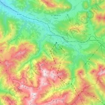
Name: Marktgemeinde Fieberbrunn topographic map, elevation, terrain.
Average elevation: 1,245 m
Minimum elevation: 672 m
Maximum elevation: 2,091 m
Other topographic maps
Click on a map to view its topography, its elevation and its terrain.
Hohe Salve
Austria > Tyrol > Bezirk Kitzbühel > Gemeinde Westendorf
Hohe Salve, Gemeinde Westendorf, Bezirk Kitzbühel, Tyrol, 6306, Austria
Average elevation: 1,360 m
Gemeinde Aurach bei Kitzbühel
Austria > Tyrol > Bezirk Kitzbühel
Gemeinde Aurach bei Kitzbühel, Bezirk Kitzbühel, Tyrol, 6371, Austria
Average elevation: 1,395 m
Itter
Austria > Tyrol > Bezirk Kitzbühel
Itter, Bezirk Kitzbühel, Tyrol, 6305, Austria
Average elevation: 811 m