Geolocate

Waxweiler topographic map

Click on the map to display elevation.

About this map

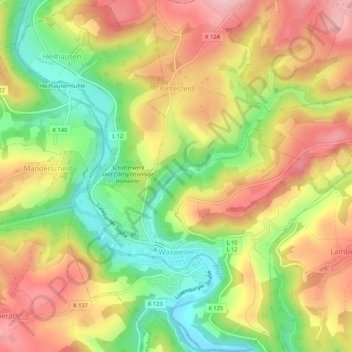
Name: Waxweiler topographic map, elevation, terrain.

Location: Waxweiler, Arzfeld, Eifelkreis Bitburg-Prüm, Rhineland-Palatinate, Germany (50.08248 6.34172 50.11642 6.39168)

Average elevation: 422 m

Minimum elevation: 322 m

Maximum elevation: 512 m

Other topographic maps

Click on a map to view its topography, its elevation and its terrain.

Gear up for your next adventure:

🧗Locking Carabiners - Secure gear to your pack or for light technical use
🗺️Ordnance Survey Maps - Essential paper maps for hiking across the UK national parks
🧊Insulated Flasks - Keeps drinks hot or cold during hikes
🛌Insulated Sleeping Mats - Crucial thermal protection when sleeping on cold, uneven ground
🎒Hiking Child Carriers - Explore the outdoors with the whole family safely

As an Amazon Associate, this site earns from qualifying purchases at no extra cost to you.