
Ohrdorf topographic map
Interactive map
Click on the map to display elevation.
About this map
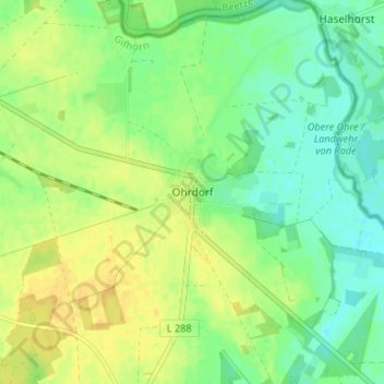
Name: Ohrdorf topographic map, elevation, terrain.
Location: Ohrdorf, Wittingen, Gifhorn, Niedersachsen, Deutschland (52.67737 10.78850 52.71737 10.82850)
Average elevation: 87 m
Minimum elevation: 75 m
Maximum elevation: 99 m
Other topographic maps
Click on a map to view its topography, its elevation and its terrain.
Erpensen
Deutschland > Niedersachsen > Gifhorn > Wittingen
Erpensen, Wittingen, Gifhorn, Niedersachsen, 29378, Deutschland
Average elevation: 82 m
Zasenbeck
Deutschland > Niedersachsen > Gifhorn > Wittingen
Zasenbeck, Wittingen, Gifhorn, Niedersachsen, Deutschland
Average elevation: 82 m
Boitzenhagen
Deutschland > Niedersachsen > Gifhorn > Wittingen
Boitzenhagen, Wittingen, Gifhorn, Niedersachsen, Deutschland
Average elevation: 95 m