
Bad Blumau topographic map
Interactive map
Click on the map to display elevation.
About this map
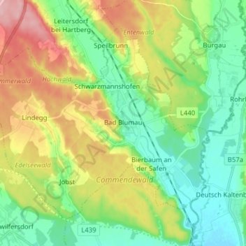
Name: Bad Blumau topographic map, elevation, terrain.
Location: Bad Blumau, Bezirk Hartberg-Fürstenfeld, Styria, 8283, Austria (47.08216 15.96950 47.14959 16.09591)
Average elevation: 303 m
Minimum elevation: 250 m
Maximum elevation: 399 m
Other topographic maps
Click on a map to view its topography, its elevation and its terrain.
Stubenberg am See
Austria > Styria > Bezirk Hartberg-Fürstenfeld > Stubenberg
Average elevation: 539 m