
Heiligenschwendi topographic map
Interactive map
Click on the map to display elevation.
About this map
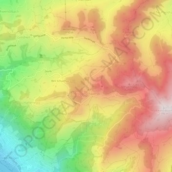
Name: Heiligenschwendi topographic map, elevation, terrain.
Average elevation: 1,007 m
Minimum elevation: 558 m
Maximum elevation: 1,384 m
Other topographic maps
Click on a map to view its topography, its elevation and its terrain.
Thunersee
Zwitserland > Bern/Berne > Verwaltungskreis Thun > Sigriswil
Thunersee, Sigriswil, Horrenbach-Buchen, Verwaltungskreis Thun, Verwaltungsregion Oberland, Bern/Berne, 3705, Zwitserland
Average elevation: 899 m