
Oudtshoorn topographic map
Interactive map
Click on the map to display elevation.
About this map
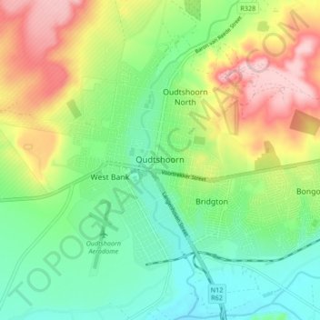
Name: Oudtshoorn topographic map, elevation, terrain.
Average elevation: 354 m
Minimum elevation: 284 m
Maximum elevation: 469 m
Other topographic maps
Click on a map to view its topography, its elevation and its terrain.
De Rust
South Africa > Western Cape > Garden Route District Municipality > Oudtshoorn Local Municipality
De Rust, Oudtshoorn Local Municipality, Garden Route District Municipality, Western Cape, 6651, South Africa
Average elevation: 544 m