
Make a donation
Gear up for your next adventure:
As an Amazon Associate, this site earns from qualifying purchases at no extra cost to you.
Bruner topographic map
Click on the map to display elevation.
Make a donation
Gear up for your next adventure:
As an Amazon Associate, this site earns from qualifying purchases at no extra cost to you.
About this map
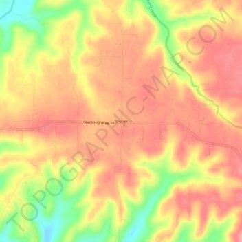
Name: Bruner topographic map, elevation, terrain.
Location: Bruner, Christian County, Missouri, 65720, United States (36.99478 -93.00601 37.03478 -92.96601)
Average elevation: 434 m
Minimum elevation: 370 m
Maximum elevation: 467 m
Make a donation
Gear up for your next adventure:
As an Amazon Associate, this site earns from qualifying purchases at no extra cost to you.
Other topographic maps
Click on a map to view its topography, its elevation and its terrain.
Clever
United States > Missouri > Christian County
Clever is located on the Springfield Plateau of the Missouri Ozarks, 14.5 miles (23.3 km) southwest of Springfield at an elevation of 1,398 feet (426 m). The town lies in the western panhandle of Christian County, just south of Missouri Highway 14 between Nixa and Billings. The town of Republic and the…
Average elevation: 397 m