
Rondón topographic map
Interactive map
Click on the map to display elevation.
Rondón
Rondón is a town and municipality in the Márquez Province, part of Boyacá Department, Colombia. The urban centre of Rondón is situated at an altitude of 2,075 metres (6,808 ft) on the Altiplano Cundiboyacense in the Colombian Eastern Ranges of the Andes. It is 61 kilometres (38 mi) away from the departmental capital Tunja. Rondón borders Viracachá and Siachoque in the north, Zetaquirá and Ramiriquí in the south, Pesca in the east and Ramiriquí and Ciénega in the west.
About this map
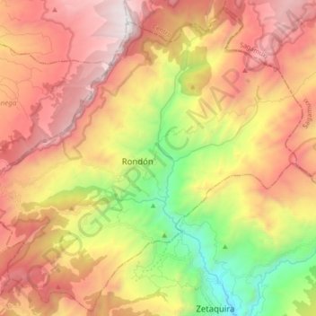
Name: Rondón topographic map, elevation, terrain.
Location: Rondón, Lengupá, Boyacá, Colombia (5.28061 -73.28690 5.43859 -73.12249)
Average elevation: 2,472 m
Minimum elevation: 1,303 m
Maximum elevation: 3,542 m
Other topographic maps
Click on a map to view its topography, its elevation and its terrain.
Garagoa
Garagoa (Spanish pronunciation: [ɡaɾaˈɣoa]) is a town and municipality in Colombia, located in the Boyacá Department. It covers an area of 191.75 km2 and the urban centre is located at an altitude of 1,650 metres (5,410 ft) above sea level. Parts of the municipality reach altitudes of 3,050 metres (10,010…
Average elevation: 1,988 m
Sogamoso
Sogamoso (Spanish pronunciation: [soɣaˈmoso]) is a city in the department of Boyacá of Colombia. It is the capital of the Sugamuxi Province, named after the original Sugamuxi. Sogamoso is nicknamed "City of the Sun", based on the original Muisca tradition of pilgrimage and adoring their Sun god Sué at the…
Average elevation: 2,901 m
Parque Natural Regional Páramo de Rabanal
Colombia > Boyacá > Guachetá > Samacá
Average elevation: 3,071 m
Gachantivá
Gachantivá is a town and municipality in the Ricaurte Province, part of the Colombian department of Boyacá. Gachantivá is located at altitudes ranging from 2,000 metres (6,600 ft) to 3,300 metres (10,800 ft) on the Altiplano Cundiboyacense and borders Villa de Leyva in the south, Santa Sofía in the west,…
Average elevation: 2,365 m
Ráquira
Ráquira, is a municipality and town in Boyacá Department, Colombia, part of the subregion of the Ricaurte Province. Ráquira is situated on the Altiplano Cundiboyacense and the urban center at an altitude of 2,150 metres (7,050 ft). It borders Tinjacá and Sutamarchán in the north, Guachetá, Cundinamarca…
Average elevation: 2,677 m
Villa de Leyva
Located away from major trade routes in a high altitude valley of semi-desert terrain, and with no mineral deposits nearby to exploit, the town has undergone little development in the last 400 years. As a consequence, it is one of the few towns in Colombia to have preserved much of its original colonial style…
Average elevation: 2,416 m
Tunja
Tunja has a population of 172,548 inhabitants according to the 2018 Census. 0.1% of the city is indigenous, 0.4% is black, and 99.5% is white and Mestizo. It is located in central Colombia. The city centre is at an elevation of 2,820 metres (9,250 ft) above sea level.
Average elevation: 2,824 m