
عمرة topographic map
Interactive map
Click on the map to display elevation.
About this map
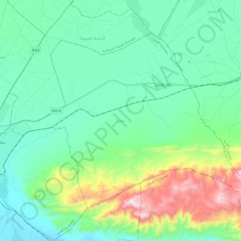
Name: عمرة topographic map, elevation, terrain.
Location: عمرة, معتمدية القصر, Gafsa, Tunisia (34.36957 8.83522 34.50209 9.05531)
Average elevation: 443 m
Minimum elevation: 239 m
Maximum elevation: 1,130 m
Other topographic maps
Click on a map to view its topography, its elevation and its terrain.
Redeyef
Tunisia > Gafsa > الرديف المحطة
Redeyef, الرديف المحطة, معتمدية الرديف, Gafsa, Tunisia
Average elevation: 585 m
أم العرائس المركزية
أم العرائس المركزية, معتمدية أم العرائس, Gafsa, Tunisia
Average elevation: 565 m