
Chiguará topographic map
Interactive map
Click on the map to display elevation.
About this map
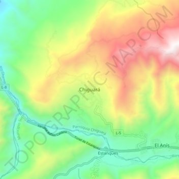
Name: Chiguará topographic map, elevation, terrain.
Average elevation: 874 m
Minimum elevation: 212 m
Maximum elevation: 1,879 m
Other topographic maps
Click on a map to view its topography, its elevation and its terrain.
La Lomita
Venezuela > Estado Mérida > Municipio Sucre
La Lomita, Parroquia Chiguará, Municipio Sucre, Estado Mérida, Venezuela
Average elevation: 1,410 m