
Thank you for supporting this site ❤️
Make a donation
Make a donation
Gear up for your next adventure:
As an Amazon Associate, this site earns from qualifying purchases at no extra cost to you.
Kionsom topographic map
Click on the map to display elevation.
Thank you for supporting this site ❤️
Make a donation
Make a donation
Gear up for your next adventure:
As an Amazon Associate, this site earns from qualifying purchases at no extra cost to you.
About this map
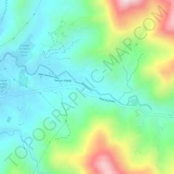
Name: Kionsom topographic map, elevation, terrain.
Location: Kionsom, Kota Kinabalu District, Sabah, Malaysia (5.97688 116.17406 5.98375 116.19393)
Average elevation: 146 m
Minimum elevation: 18 m
Maximum elevation: 422 m
Thank you for supporting this site ❤️
Make a donation
Make a donation
Gear up for your next adventure:
As an Amazon Associate, this site earns from qualifying purchases at no extra cost to you.