
Karlshorst topographic map
Interactive map
Click on the map to display elevation.
About this map
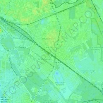
Name: Karlshorst topographic map, elevation, terrain.
Location: Karlshorst, Lichtenberg, Berlin, 10318, Deutschland (52.46784 13.50154 52.49829 13.55260)
Average elevation: 38 m
Minimum elevation: 31 m
Maximum elevation: 45 m
Other topographic maps
Click on a map to view its topography, its elevation and its terrain.
Charlottenburg
Charlottenburg, Charlottenburg-Wilmersdorf, Berlin, Deutschland
Average elevation: 41 m
Wartenberg
Deutschland > Berlin > Berlin > Siedlung Wartenberg
Wartenberg, Lichtenberg, Siedlung Wartenberg, Berlin, 13059, Deutschland
Average elevation: 59 m