
Make a donation
Gear up for your next adventure:
As an Amazon Associate, this site earns from qualifying purchases at no extra cost to you.
Monte Soratte topographic map
Click on the map to display elevation.
Make a donation
Gear up for your next adventure:
As an Amazon Associate, this site earns from qualifying purchases at no extra cost to you.
Monte Soratte
Il Soratte ha una pianta a forma di ellissoide avente un asse longitudinale che si sviluppa per circa 5,5 km in direzione NNO-SSE secondo un profilo a forma di arco composto da sei cime, su una delle quali, a circa 400 m di altitudine, si trova il paese di Sant'Oreste.
Make a donation
Gear up for your next adventure:
As an Amazon Associate, this site earns from qualifying purchases at no extra cost to you.
About this map
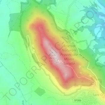
Name: Monte Soratte topographic map, elevation, terrain.
Location: Monte Soratte, Sant'Oreste, Roma Capitale, Lazio, Italia (42.24557 12.50189 42.24567 12.50199)
Average elevation: 308 m
Minimum elevation: 86 m
Maximum elevation: 669 m
Make a donation
Gear up for your next adventure:
As an Amazon Associate, this site earns from qualifying purchases at no extra cost to you.