Geolocate

Whitacre topographic map

Click on the map to display elevation.

About this map
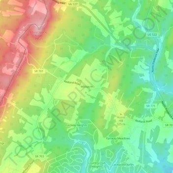
Name: Whitacre topographic map, elevation, terrain.

Location: Whitacre, Frederick County, Virginia, 22625, United States (39.31232 -78.34723 39.35232 -78.30723)

Average elevation: 303 m

Minimum elevation: 233 m

Maximum elevation: 400 m

Other topographic maps

Click on a map to view its topography, its elevation and its terrain.
Gore

United States > Virginia > Frederick County > Gore

Average elevation: 255 m

Brucetown

United States > Virginia > Frederick County > Brucetown

Average elevation: 176 m

Middletown

United States > Virginia > Frederick County

Average elevation: 211 m

Gore

United States > Virginia > Frederick County > Gore

Average elevation: 255 m

Gear up for your next adventure:

🎒Hiking Child Carriers - Explore the outdoors with the whole family safely
🔥Reusable Hand Warmers - Maintain dexterity in your fingers for precise map handling
🧵Survival Paracord - Multi-purpose cordage for emergency repairs and shelters
🧭Orienteering Compasses - Accurate compasses for map-based navigation
🛑Emergency Bivvy Bags - Heat-reflective survival bags for unexpected nights out

As an Amazon Associate, this site earns from qualifying purchases at no extra cost to you.