Geolocate

Garner topographic map

Click on the map to display elevation.

About this map

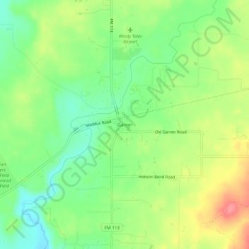
Name: Garner topographic map, elevation, terrain.

Location: Garner, Parker County, Texas, United States (32.81318 -98.00532 32.85318 -97.96532)

Average elevation: 296 m

Minimum elevation: 261 m

Maximum elevation: 343 m

Other topographic maps

Click on a map to view its topography, its elevation and its terrain.

Weatherford

United States > Texas > Parker County

Average elevation: 326 m

Reno

United States > Texas > Parker County

Average elevation: 233 m

Aledo

United States > Texas > Parker County

Average elevation: 271 m

Springtown

United States > Texas > Parker County

Average elevation: 273 m

Millsap

United States > Texas > Parker County

Average elevation: 257 m

Snake Forest

United States > Texas > Parker County

Average elevation: 312 m

Aledo

United States > Texas > Parker County

Average elevation: 271 m

Weatherford

United States > Texas > Parker County

Average elevation: 326 m

Gear up for your next adventure:

🛌Insulated Sleeping Mats - Crucial thermal protection when sleeping on cold, uneven ground
🧺Mesh Stuff Sacks - Breathable storage for wet gear or camp organization
🥾Hiking Boots - Waterproof and durable boots for long-distance hiking in the UK
🥾Walking Shoes - Lightweight walking shoes for countryside and coastal paths
🧥Breathable Waterproof Jackets - Essential rain protection for the unpredictable British climate

As an Amazon Associate, this site earns from qualifying purchases at no extra cost to you.