
Pryor Creek topographic map
Interactive map
Click on the map to display elevation.
About this map
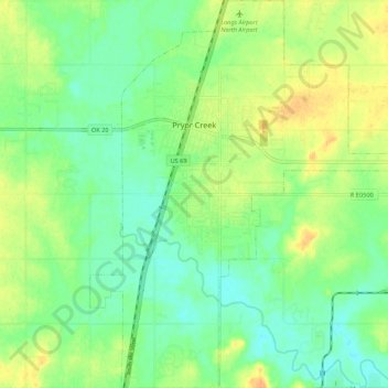
Name: Pryor Creek topographic map, elevation, terrain.
Location: Pryor Creek, Mayes County, Oklahoma, United States (36.24938 -95.34592 36.33632 -95.25620)
Average elevation: 190 m
Minimum elevation: 176 m
Maximum elevation: 209 m
Other topographic maps
Click on a map to view its topography, its elevation and its terrain.
Grand Lake Towne
United States > Oklahoma > Mayes County
Grand Lake Towne, Mayes County, Oklahoma, United States
Average elevation: 234 m
Salina
United States > Oklahoma > Mayes County > Salina
Salina, Mayes County, Oklahoma, United States
Average elevation: 202 m
Disney
United States > Oklahoma > Mayes County > Disney
Disney, Mayes County, Oklahoma, United States
Average elevation: 228 m
Adair
United States > Oklahoma > Mayes County > Adair
Adair, Mayes County, Oklahoma, 74330, United States
Average elevation: 206 m