
Thank you for supporting this site ❤️
Make a donation
Make a donation
Gear up for your next adventure:
As an Amazon Associate, this site earns from qualifying purchases at no extra cost to you.
Innsbrook topographic map
Click on the map to display elevation.
Thank you for supporting this site ❤️
Make a donation
Make a donation
Gear up for your next adventure:
As an Amazon Associate, this site earns from qualifying purchases at no extra cost to you.
About this map
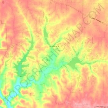
Name: Innsbrook topographic map, elevation, terrain.
Location: Innsbrook, Warren County, Missouri, United States (38.73132 -91.09815 38.79685 -91.00590)
Average elevation: 232 m
Minimum elevation: 166 m
Maximum elevation: 272 m
Thank you for supporting this site ❤️
Make a donation
Make a donation
Gear up for your next adventure:
As an Amazon Associate, this site earns from qualifying purchases at no extra cost to you.
Other topographic maps
Click on a map to view its topography, its elevation and its terrain.
Little Lost Creek Conservation Area
United States > Missouri > Warren County > Pendleton
Average elevation: 241 m