
Make a donation
Gear up for your next adventure:
As an Amazon Associate, this site earns from qualifying purchases at no extra cost to you.
Armonk topographic map
Click on the map to display elevation.
Make a donation
Gear up for your next adventure:
As an Amazon Associate, this site earns from qualifying purchases at no extra cost to you.
Armonk
Situated 11 miles from the coast in the southeastern corner of New York, Armonk shares a border with Connecticut. The landscape is hilly and forested with a mean elevation of 387 feet.
Make a donation
Gear up for your next adventure:
As an Amazon Associate, this site earns from qualifying purchases at no extra cost to you.
About this map
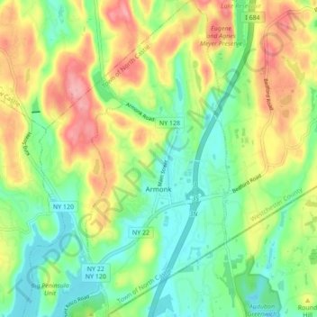
Name: Armonk topographic map, elevation, terrain.
Average elevation: 155 m
Minimum elevation: 107 m
Maximum elevation: 228 m
Make a donation
Gear up for your next adventure:
As an Amazon Associate, this site earns from qualifying purchases at no extra cost to you.
Other topographic maps
Click on a map to view its topography, its elevation and its terrain.