
Make a donation
Gear up for your next adventure:
As an Amazon Associate, this site earns from qualifying purchases at no extra cost to you.
Homs Governorate topographic map
Click on the map to display elevation.
Make a donation
Gear up for your next adventure:
As an Amazon Associate, this site earns from qualifying purchases at no extra cost to you.
About this map
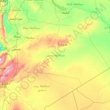
Name: Homs Governorate topographic map, elevation, terrain.
Location: Homs Governorate, Syria (33.55189 36.10542 35.39111 40.16275)
Average elevation: 604 m
Minimum elevation: 95 m
Maximum elevation: 3,015 m
Make a donation
Gear up for your next adventure:
As an Amazon Associate, this site earns from qualifying purchases at no extra cost to you.
Other topographic maps
Click on a map to view its topography, its elevation and its terrain.
Make a donation
Gear up for your next adventure:
As an Amazon Associate, this site earns from qualifying purchases at no extra cost to you.
Make a donation
Gear up for your next adventure:
As an Amazon Associate, this site earns from qualifying purchases at no extra cost to you.
Deir Atiya
Syria > Rif Dimashq Governorate
Deir Atiyah enjoys a moderate climate in summer and cold in the winter as it is located at an altitude of 1,250 metres (4,100 ft) above sea level.
Average elevation: 1,268 m
Make a donation
Gear up for your next adventure:
As an Amazon Associate, this site earns from qualifying purchases at no extra cost to you.
Beludan
Syria > Rif Dimashq Governorate
Bloudan (Arabic: بلودان, romanized: Blūdān) is a Syrian village located 51 kilometers north-west of Damascus, in the Rif Dimashq Governorate; it has an altitude of about 1500 meters. In the 2004 census by the Central Bureau of Statistics it had a population of 3,101. The majority of the inhabitants are…
Average elevation: 1,564 m
Make a donation
Gear up for your next adventure:
As an Amazon Associate, this site earns from qualifying purchases at no extra cost to you.
Khan Shaykhun
Syria > Idleb Governorate > Khan Shaykhoun
Khan Shaykhun is located at an altitude of 350 meters on the main highway between Aleppo and Damascus. The local economy is primarily agricultural, focusing on the growing of cotton and cereals. The town was formerly known for producing embroidery. Nearby localities include Hbit to the west, Kafr Zita to…
Average elevation: 374 m
Make a donation
Gear up for your next adventure:
As an Amazon Associate, this site earns from qualifying purchases at no extra cost to you.
Make a donation
Gear up for your next adventure:
As an Amazon Associate, this site earns from qualifying purchases at no extra cost to you.
Barada River
Syria > Damascus Governorate > Damascus Subdistrict > Al-Qanawat Municipality
Average elevation: 703 m
Make a donation
Gear up for your next adventure:
As an Amazon Associate, this site earns from qualifying purchases at no extra cost to you.
Make a donation
Gear up for your next adventure:
As an Amazon Associate, this site earns from qualifying purchases at no extra cost to you.
Make a donation
Gear up for your next adventure:
As an Amazon Associate, this site earns from qualifying purchases at no extra cost to you.
Make a donation
Gear up for your next adventure:
As an Amazon Associate, this site earns from qualifying purchases at no extra cost to you.
Make a donation
Gear up for your next adventure:
As an Amazon Associate, this site earns from qualifying purchases at no extra cost to you.
Tadmur
With the elevation of Palmyra to a colonia around 213–216, the city ceased being subject to Roman provincial governors and taxes. Palmyra incorporated Roman institutions into its system while keeping many of its former ones. The council remained, and the strategos designated one of two annually-elected…
Average elevation: 499 m
Dummar
Syria > Damascus Governorate > Damascus Subdistrict > Dummar Municipality
Average elevation: 864 m
Make a donation
Gear up for your next adventure:
As an Amazon Associate, this site earns from qualifying purchases at no extra cost to you.
Make a donation
Gear up for your next adventure:
As an Amazon Associate, this site earns from qualifying purchases at no extra cost to you.
Make a donation
Gear up for your next adventure:
As an Amazon Associate, this site earns from qualifying purchases at no extra cost to you.
Izra
Izraa or Izra (Arabic: إِزْرَع, romanized: Izraʿ) is a city in the Daraa Governorate of Syria, to the north of the city of Daraa. It is the administrative centre of the Izraa District, and sits at an altitude of 599 metres. According to the Syria Central Bureau of Statistics (CBS), Izraa had a…
Average elevation: 583 m
Make a donation
Gear up for your next adventure:
As an Amazon Associate, this site earns from qualifying purchases at no extra cost to you.
Make a donation
Gear up for your next adventure:
As an Amazon Associate, this site earns from qualifying purchases at no extra cost to you.
Make a donation
Gear up for your next adventure:
As an Amazon Associate, this site earns from qualifying purchases at no extra cost to you.
Make a donation
Gear up for your next adventure:
As an Amazon Associate, this site earns from qualifying purchases at no extra cost to you.
Al-Qusair
Al-Qusayr (Arabic: القصير, romanized: al-Quṣayr, Levantine Arabic pronunciation: [elʔʊˈsˤeːɾ], Standard Arabic: [alqʊˈsˤeːr, alqʊˈsˤɑjr]) is a city in western Syria, administratively part of the Homs Governorate. It is located about 35 kilometers (22 mi) south of Homs and is situated in a…
Average elevation: 540 m
Make a donation
Gear up for your next adventure:
As an Amazon Associate, this site earns from qualifying purchases at no extra cost to you.
Idlib
Idlib (Arabic: إِدْلِب, romanized: ʾIdlib, pronounced [ʔid.lib]; also spelt Idleb or Edlib) is a city in northwestern Syria, and is the capital of the Idlib Governorate. It has an elevation of nearly 500 meters (1,600 ft) above sea level, and is 59 kilometers (37 mi) southwest of Aleppo. It is located…
Average elevation: 394 m
Al Mazzeh
Syria > Damascus Governorate > Damascus Subdistrict > Al-Mazza Municipality
Average elevation: 790 m
Make a donation
Gear up for your next adventure:
As an Amazon Associate, this site earns from qualifying purchases at no extra cost to you.
Make a donation
Gear up for your next adventure:
As an Amazon Associate, this site earns from qualifying purchases at no extra cost to you.
Make a donation
Gear up for your next adventure:
As an Amazon Associate, this site earns from qualifying purchases at no extra cost to you.
Make a donation
Gear up for your next adventure:
As an Amazon Associate, this site earns from qualifying purchases at no extra cost to you.
Jabal Ash Shaykh
Syria > Rif Dimashq Governorate
On the top, in the United Nations buffer zone between Syrian and Israeli-occupied territories, is the highest permanently manned UN position in the world, known as "Hermon Hotel", located at 2,814 metres (9,232 ft). The southern slopes of Mount Hermon extend to the Israeli-occupied portion of the Golan…
Average elevation: 2,516 m
Make a donation
Gear up for your next adventure:
As an Amazon Associate, this site earns from qualifying purchases at no extra cost to you.
Make a donation
Gear up for your next adventure:
As an Amazon Associate, this site earns from qualifying purchases at no extra cost to you.