
Make a donation
Gear up for your next adventure:
As an Amazon Associate, this site earns from qualifying purchases at no extra cost to you.
Damascus topographic map
Click on the map to display elevation.
Make a donation
Gear up for your next adventure:
As an Amazon Associate, this site earns from qualifying purchases at no extra cost to you.
About this map
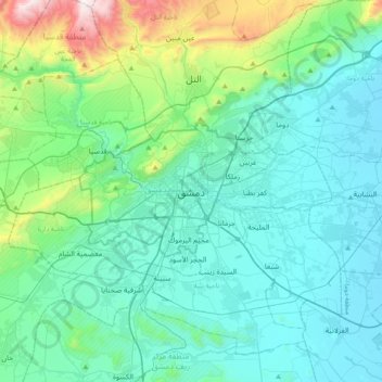
Name: Damascus topographic map, elevation, terrain.
Average elevation: 828 m
Minimum elevation: 607 m
Maximum elevation: 1,956 m
Make a donation
Gear up for your next adventure:
As an Amazon Associate, this site earns from qualifying purchases at no extra cost to you.
Other topographic maps
Click on a map to view its topography, its elevation and its terrain.
Barada River
Syria > Damascus Governorate > Damascus Subdistrict > Al-Qanawat Municipality
Average elevation: 703 m
Al-Muhajerin Municipality
Syria > Damascus Governorate > Damascus Subdistrict
Average elevation: 797 m
Make a donation
Gear up for your next adventure:
As an Amazon Associate, this site earns from qualifying purchases at no extra cost to you.
Tishreen Park
Syria > Damascus Governorate > Damascus Subdistrict > Al-Muhajerin Municipality
Average elevation: 771 m
Make a donation
Gear up for your next adventure:
As an Amazon Associate, this site earns from qualifying purchases at no extra cost to you.
Masakin Barza Neighborhood
Syria > Damascus Governorate > Damascus Subdistrict > Barza Municipality > Barzeh
Average elevation: 747 m
Make a donation
Gear up for your next adventure:
As an Amazon Associate, this site earns from qualifying purchases at no extra cost to you.
Al-Muhajerin Municipality
Syria > Damascus Governorate > Damascus Subdistrict
Average elevation: 797 m
Al-Muhajerin Municipality
Syria > Damascus Governorate > Damascus Subdistrict
Average elevation: 797 m
Make a donation
Gear up for your next adventure:
As an Amazon Associate, this site earns from qualifying purchases at no extra cost to you.
Mazzeh 86 Neighborhood
Syria > Damascus Governorate > Damascus Subdistrict > Al-Mazza Municipality > Al Mazzeh
Average elevation: 811 m
Make a donation
Gear up for your next adventure:
As an Amazon Associate, this site earns from qualifying purchases at no extra cost to you.
Al-Muhajerin Municipality
Syria > Damascus Governorate > Damascus Subdistrict
Average elevation: 797 m
Al Mazra'a Neighborhood
Syria > Damascus Governorate > Damascus Subdistrict > As-Salihiya Municipality
Average elevation: 720 m
Ash-Shaghour Municipality
Syria > Damascus Governorate > Damascus Subdistrict
Average elevation: 680 m
Make a donation
Gear up for your next adventure:
As an Amazon Associate, this site earns from qualifying purchases at no extra cost to you.