
Jabal Qasiyun topographic map
Interactive map
Click on the map to display elevation.
About this map
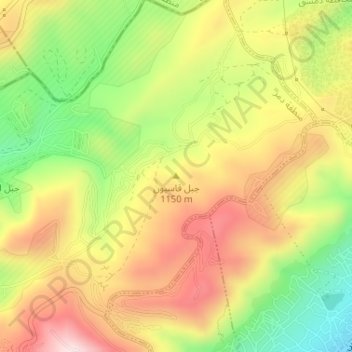
Name: Jabal Qasiyun topographic map, elevation, terrain.
Average elevation: 946 m
Minimum elevation: 735 m
Maximum elevation: 1,142 m
The mountain is also host to an endemic species of iris, Iris damascena, which can be found on the steep eastern slopes, at an altitude of 1,200 m (3,900 ft) above sea level.[5] The Syrian government has not given the species any protected status. Its only benefiting factor was that part of the habitat of the species lies within a military area near the 'Qassioun Republican Guards Military Base' and other military facilities, which prevents civilians from accessing the area.[6] The base and steepness of the habitat also prevents construction or development, but it is still classified as Critically endangered.[7]