Geolocate

Brandon topographic map

Click on the map to display elevation.

About this map

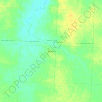
Name: Brandon topographic map, elevation, terrain.

Location: Brandon, Benton County, Missouri, United States (38.48807 -93.44299 38.52807 -93.40299)

Average elevation: 281 m

Minimum elevation: 269 m

Maximum elevation: 294 m

Other topographic maps

Click on a map to view its topography, its elevation and its terrain.

Cole Camp

United States > Missouri > Benton County

Average elevation: 312 m

Warsaw

United States > Missouri > Benton County

Average elevation: 218 m

Cole Camp

United States > Missouri > Benton County

Average elevation: 312 m

Gear up for your next adventure:

🐕Hiking Dog Harnesses - Rugged harnesses for taking your companion on mountain trails
🍲Portable Camping Stoves - Fast-boiling stoves for hot meals on remote topographic survey trips
🔦Keychain LED Torches - Emergency backup light for finding gear in your pack
🚲Cycling GPS Computers - Track elevation and topographic routes on two wheels
🔪Outdoor Multi-Tools - Versatile tools for gear repairs and food prep in the wild

As an Amazon Associate, this site earns from qualifying purchases at no extra cost to you.