
Make a donation
Gear up for your next adventure:
As an Amazon Associate, this site earns from qualifying purchases at no extra cost to you.
Viroqua topographic map
Click on the map to display elevation.
Make a donation
Gear up for your next adventure:
As an Amazon Associate, this site earns from qualifying purchases at no extra cost to you.
About this map
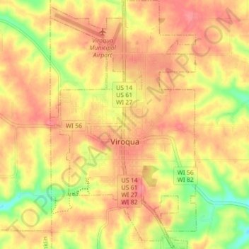
Name: Viroqua topographic map, elevation, terrain.
Location: Viroqua, Vernon County, Wisconsin, 54665, United States (43.53494 -90.90976 43.58565 -90.86867)
Average elevation: 376 m
Minimum elevation: 330 m
Maximum elevation: 402 m
Make a donation
Gear up for your next adventure:
As an Amazon Associate, this site earns from qualifying purchases at no extra cost to you.
Other topographic maps
Click on a map to view its topography, its elevation and its terrain.
Wildcat Mountain State Park
United States > Wisconsin > Vernon County > Town of Whitestown
Average elevation: 310 m
Make a donation
Gear up for your next adventure:
As an Amazon Associate, this site earns from qualifying purchases at no extra cost to you.
Wildcat Mountain State Park
United States > Wisconsin > Vernon County > Town of Whitestown
Average elevation: 310 m