
Make a donation
Gear up for your next adventure:
As an Amazon Associate, this site earns from qualifying purchases at no extra cost to you.
Iraq Al-Amir topographic map
Click on the map to display elevation.
Make a donation
Gear up for your next adventure:
As an Amazon Associate, this site earns from qualifying purchases at no extra cost to you.
Iraq Al-Amir
'Iraq al-Amir or Araq el-Amir (Arabic:عراق الأمير - literally, "Caves of the Prince"), is the name shared by a town and nearby caves, within the municipality of Amman in the Jordan Valley. Located about 15 km southwest of the town of Wadi as-Seer, it has a population of about 6000 people, mostly members of the Abbadi tribe. It is located on hills with high and medium altitude, in an area with many springs and famous for its olive trees and other forest trees.
Make a donation
Gear up for your next adventure:
As an Amazon Associate, this site earns from qualifying purchases at no extra cost to you.
About this map
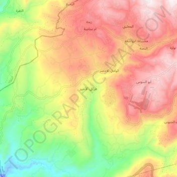
Name: Iraq Al-Amir topographic map, elevation, terrain.
Average elevation: 487 m
Minimum elevation: -49 m
Maximum elevation: 932 m
Make a donation
Gear up for your next adventure:
As an Amazon Associate, this site earns from qualifying purchases at no extra cost to you.
Other topographic maps
Click on a map to view its topography, its elevation and its terrain.