Geolocate

Max Meadows topographic map

Click on the map to display elevation.

About this map

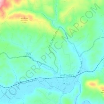
Name: Max Meadows topographic map, elevation, terrain.

Location: Max Meadows, Wythe County, Virginia, United States (36.96319 -80.99734 36.99965 -80.94156)

Average elevation: 662 m

Minimum elevation: 606 m

Maximum elevation: 830 m

Other topographic maps

Click on a map to view its topography, its elevation and its terrain.

Galena

United States > Virginia > Wythe County

Average elevation: 642 m

Crockett

United States > Virginia > Wythe County

Average elevation: 750 m

West Piney

United States > Virginia > Wythe County

Average elevation: 740 m

Cripple Creek

United States > Virginia > Wythe County > Speedwell

Average elevation: 733 m

Austinville

United States > Virginia > Wythe County

Average elevation: 645 m

Barren Springs

United States > Virginia > Wythe County

Average elevation: 642 m

Ivanhoe

United States > Virginia > Wythe County

Average elevation: 643 m

Gear up for your next adventure:

🧊Insulated Flasks - Keeps drinks hot or cold during hikes
🐕Dog Hiking Gear - Equipment for hiking safely with dogs
🥤Collapsible Water Bottles - Save space in your rucksack as you consume your water
Insulated Travel Mugs - Keep drinks hot while surveying the landscape from a summit
🧣Fleece Neck Warmers - Extra insulation for winter topographic surveys

As an Amazon Associate, this site earns from qualifying purchases at no extra cost to you.