
Make a donation
Gear up for your next adventure:
As an Amazon Associate, this site earns from qualifying purchases at no extra cost to you.
Max Meadows topographic map
Click on the map to display elevation.
Make a donation
Gear up for your next adventure:
As an Amazon Associate, this site earns from qualifying purchases at no extra cost to you.
About this map
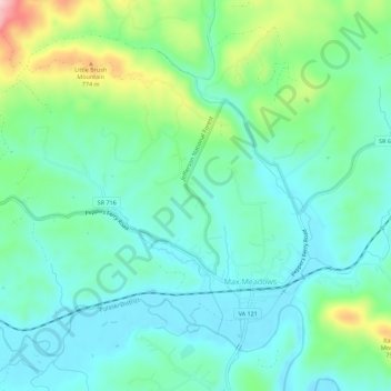
Name: Max Meadows topographic map, elevation, terrain.
Location: Max Meadows, Wythe County, Virginia, United States (36.96319 -80.99734 36.99965 -80.94156)
Average elevation: 662 m
Minimum elevation: 606 m
Maximum elevation: 830 m
Make a donation
Gear up for your next adventure:
As an Amazon Associate, this site earns from qualifying purchases at no extra cost to you.
Other topographic maps
Click on a map to view its topography, its elevation and its terrain.
Make a donation
Gear up for your next adventure:
As an Amazon Associate, this site earns from qualifying purchases at no extra cost to you.
Stones Mill
United States > Virginia > Wythe County > Wytheville > Stones Mill
Average elevation: 710 m
Make a donation
Gear up for your next adventure:
As an Amazon Associate, this site earns from qualifying purchases at no extra cost to you.