
Pocahontas topographic map
Interactive map
Click on the map to display elevation.
About this map
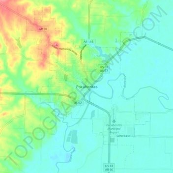
Name: Pocahontas topographic map, elevation, terrain.
Location: Pocahontas, Randolph County, Arkansas, 72455, United States (36.22122 -91.01110 36.30122 -90.93110)
Average elevation: 94 m
Minimum elevation: 73 m
Maximum elevation: 152 m
Other topographic maps
Click on a map to view its topography, its elevation and its terrain.
Sand Hill
United States > Arkansas > Randolph County > Pocahontas
Sand Hill, Pocahontas, Randolph County, Arkansas, 72455, United States
Average elevation: 118 m
Pocahontas
United States > Arkansas > Randolph County > Pocahontas
Pocahontas, Randolph County, Arkansas, United States
Average elevation: 96 m