
Make a donation
Gear up for your next adventure:
As an Amazon Associate, this site earns from qualifying purchases at no extra cost to you.
Ogulin topographic map
Click on the map to display elevation.
Make a donation
Gear up for your next adventure:
As an Amazon Associate, this site earns from qualifying purchases at no extra cost to you.
About this map
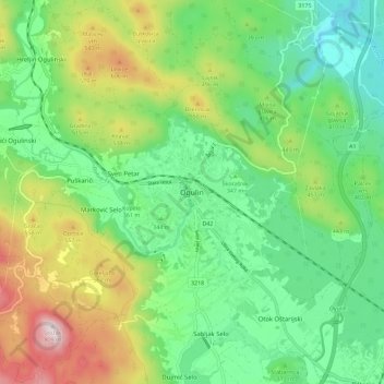
Name: Ogulin topographic map, elevation, terrain.
Location: Ogulin, Grad Ogulin, Karlovac County, 47300, Croatia (45.22586 15.18552 45.30586 15.26552)
Average elevation: 391 m
Minimum elevation: 188 m
Maximum elevation: 793 m
Make a donation
Gear up for your next adventure:
As an Amazon Associate, this site earns from qualifying purchases at no extra cost to you.
Other topographic maps
Click on a map to view its topography, its elevation and its terrain.
Jasenak
A weather station exists there at an elevation of 618 metres (2,028 ft). The minimum recorded temperature for the winter of 2024–2025 was −16.7 °C (1.9 °F), on February 20.
Average elevation: 884 m
Make a donation
Gear up for your next adventure:
As an Amazon Associate, this site earns from qualifying purchases at no extra cost to you.
Make a donation
Gear up for your next adventure:
As an Amazon Associate, this site earns from qualifying purchases at no extra cost to you.
Grad Ogulin
Since records began in 1949, the highest temperature recorded at the local weather station at an elevation of 328 metres (1,076 ft) was 39.5 °C (103.1 °F), on 5 July 1950. The coldest temperature was −28.5 °C (−19.3 °F), on 17 February 1956.
Average elevation: 487 m
Make a donation
Gear up for your next adventure:
As an Amazon Associate, this site earns from qualifying purchases at no extra cost to you.