Geolocate

Arad topographic map

Click on the map to display elevation.

About this map

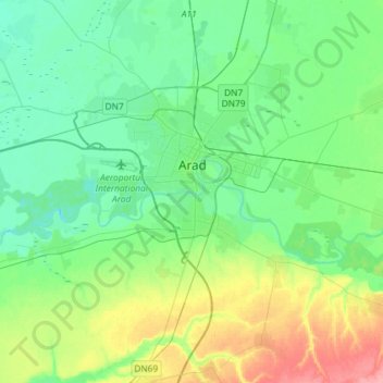
Name: Arad topographic map, elevation, terrain.

Location: Arad, Romania (46.04475 21.15136 46.26182 21.41468)

Average elevation: 120 m

Minimum elevation: 96 m

Maximum elevation: 182 m

Other topographic maps

Click on a map to view its topography, its elevation and its terrain.

Toc

Romania > Arad

Average elevation: 235 m

Mihaiasa

Romania > Arad > Săvârșin

Average elevation: 527 m

Târnova

Romania > Arad

Average elevation: 129 m

Lupești

Romania > Arad

Average elevation: 278 m

Munar

Romania > Arad

Average elevation: 101 m

Obârșia

Romania > Arad

Average elevation: 437 m

Munar

Romania > Arad > Munar

Average elevation: 101 m

Gear up for your next adventure:

📦Dry Bags - Waterproof bags to protect gear from rain
🧢Hiking Hats - Sun and weather protection for outdoor walks
🛰️Satellite Messengers - Emergency communication devices for areas without mobile signal
🧦Hiking Socks - Breathable socks designed to prevent blisters on long walks
🎒Multi-day Trekking Packs - Large capacity backpacks for wild camping and long-distance trails

As an Amazon Associate, this site earns from qualifying purchases at no extra cost to you.