Geolocate

Crescent topographic map

Click on the map to display elevation.

About this map

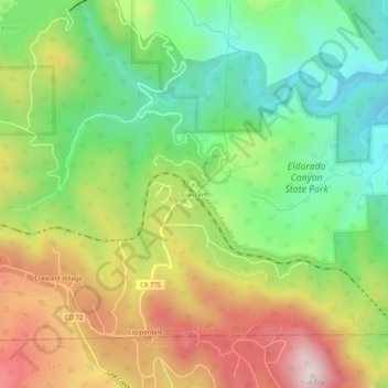
Name: Crescent topographic map, elevation, terrain.

Location: Crescent, Boulder County, Colorado, United States (39.90832 -105.36277 39.94832 -105.32277)

Average elevation: 2,266 m

Minimum elevation: 1,978 m

Maximum elevation: 2,655 m

Gear up for your next adventure:

🪓Outdoor Multitools - Versatile tools for hiking and camping
🔥Reusable Hand Warmers - Maintain dexterity in your fingers for precise map handling
🧥Breathable Waterproof Jackets - Essential rain protection for the unpredictable British climate
📦Dry Bags - Waterproof bags to protect gear from rain
🔋Rechargeable Batteries - Eco-friendly power for headlamps and older GPS units

As an Amazon Associate, this site earns from qualifying purchases at no extra cost to you.