
Wielogłowy topographic map
Interactive map
Click on the map to display elevation.
About this map
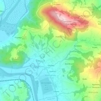
Name: Wielogłowy topographic map, elevation, terrain.
Average elevation: 354 m
Minimum elevation: 259 m
Maximum elevation: 578 m
Other topographic maps
Click on a map to view its topography, its elevation and its terrain.
Szklana
Polen > Woiwodschap Klein-Polen > powiat nowosądecki > Wielogłowy > Szklana
Szklana, Wielogłowy, gmina Chełmiec, powiat nowosądecki, Woiwodschap Klein-Polen, 33-311, Polen
Average elevation: 334 m