
Batchewana topographic map
Click on the map to display elevation.
About this map
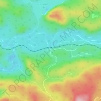
Name: Batchewana topographic map, elevation, terrain.
Average elevation: 370 m
Minimum elevation: 291 m
Maximum elevation: 514 m
Other topographic maps
Click on a map to view its topography, its elevation and its terrain.
Kabinakagami Lake
Canada > Ontario > Algoma District > Unorganized North Algoma
Average elevation: 332 m
Lucille Lake;Wood Creek
Canada > Ontario > Algoma District > Unorganized North Algoma
Average elevation: 441 m
Kirkpatrick Lake
Canada > Ontario > Algoma District > Unorganized North Algoma
Average elevation: 429 m
Kimiwan Creek;Kimiwan Lakes
Canada > Ontario > Algoma District > Unorganized North Algoma
Average elevation: 442 m
Montreal Island
Canada > Ontario > Algoma District > Unorganized North Algoma
Average elevation: 190 m
Kabinakagamisis Lake
Canada > Ontario > Algoma District > Unorganized North Algoma
Average elevation: 324 m