
Thank you for supporting this site ❤️
Make a donation
Make a donation
Gear up for your next adventure:
As an Amazon Associate, this site earns from qualifying purchases at no extra cost to you.
&Beyond Bataleur Camp topographic map
Click on the map to display elevation.
Thank you for supporting this site ❤️
Make a donation
Make a donation
Gear up for your next adventure:
As an Amazon Associate, this site earns from qualifying purchases at no extra cost to you.
About this map
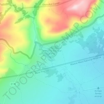
Name: &Beyond Bataleur Camp topographic map, elevation, terrain.
Location: &Beyond Bataleur Camp, Transmara West, Narok, Kenya (-1.26950 34.99056 -1.22950 35.03056)
Average elevation: 1,657 m
Minimum elevation: 1,562 m
Maximum elevation: 1,885 m
Thank you for supporting this site ❤️
Make a donation
Make a donation
Gear up for your next adventure:
As an Amazon Associate, this site earns from qualifying purchases at no extra cost to you.
Other topographic maps
Click on a map to view its topography, its elevation and its terrain.