
Grintovec topographic map
Interactive map
Click on the map to display elevation.
About this map
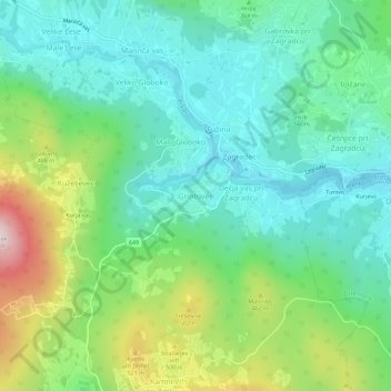
Name: Grintovec topographic map, elevation, terrain.
Location: Grintovec, Ivančna Gorica, 1303, Slovenia (45.83555 14.80800 45.87555 14.84800)
Average elevation: 363 m
Minimum elevation: 233 m
Maximum elevation: 680 m
Grintovec is the highest mountain of the Kamnik–Savinja Alps, with an elevation of 2,558 metres (8,392 ft). It is a popular location for hiking, climbing and skiing. The first recorded ascent was in 1759 by the botanist Giovanni Antonio Scopoli.