Geolocate

Modena topographic map

Click on the map to display elevation.

About this map

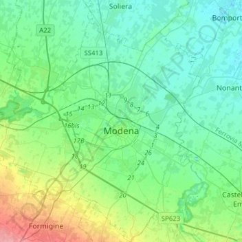
Name: Modena topographic map, elevation, terrain.

Location: Modena, Emilia-Romagna, Italy (44.56295 10.78208 44.74244 11.01227)

Average elevation: 40 m

Minimum elevation: 21 m

Maximum elevation: 104 m

Gear up for your next adventure:

🛌Sleeping Bags - Warm and packable sleeping bags for outdoor nights
👖Packable Overtrousers - Quick-deploy rain protection for legs in sudden storms
🍲Portable Camping Stoves - Fast-boiling stoves for hot meals on remote topographic survey trips
🧊Personal Water Filters - Drink safely from mountain streams marked on your map
🔦LED Camping Lanterns - Illumination for reading maps inside your tent at night

As an Amazon Associate, this site earns from qualifying purchases at no extra cost to you.