
Make a donation
Gear up for your next adventure:
As an Amazon Associate, this site earns from qualifying purchases at no extra cost to you.
Le Praz topographic map
Click on the map to display elevation.
Make a donation
Gear up for your next adventure:
As an Amazon Associate, this site earns from qualifying purchases at no extra cost to you.
About this map
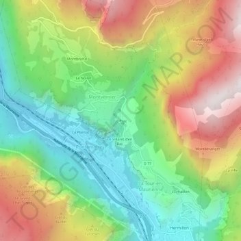
Name: Le Praz topographic map, elevation, terrain.
Average elevation: 1,021 m
Minimum elevation: 469 m
Maximum elevation: 1,798 m
Make a donation
Gear up for your next adventure:
As an Amazon Associate, this site earns from qualifying purchases at no extra cost to you.
Other topographic maps
Click on a map to view its topography, its elevation and its terrain.
Montpascal
France > Auvergne-Rhône-Alpes > Savoie > La Tour-en-Maurienne
Au cœur de la plus longue vallée des Alpes, à 502 mètres d’altitude, Pontamafrey qui est le chef-lieu de la commune est situé en fond de vallée de la Maurienne, à 4 kilomètres à l’Ouest de Saint-Jean-de-Maurienne et à 6 kilomètres à l’Est de La Chambre, en rive droite de la rivière Arc.
Average elevation: 1,545 m