
Make a donation
Gear up for your next adventure:
As an Amazon Associate, this site earns from qualifying purchases at no extra cost to you.
Roach topographic map
Click on the map to display elevation.
Make a donation
Gear up for your next adventure:
As an Amazon Associate, this site earns from qualifying purchases at no extra cost to you.
About this map
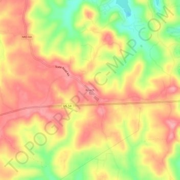
Name: Roach topographic map, elevation, terrain.
Location: Roach, Camden County, Missouri, United States (37.97392 -92.85630 38.01392 -92.81630)
Average elevation: 263 m
Minimum elevation: 191 m
Maximum elevation: 310 m
Make a donation
Gear up for your next adventure:
As an Amazon Associate, this site earns from qualifying purchases at no extra cost to you.
Other topographic maps
Click on a map to view its topography, its elevation and its terrain.
Make a donation
Gear up for your next adventure:
As an Amazon Associate, this site earns from qualifying purchases at no extra cost to you.
Linn Creek
United States > Missouri > Camden County
In 1929, it was announced that the Bagnell Dam would be constructed and the town would be flooded, causing controversy among the city's citizens. Almost all of the buildings were demolished, and the city was moved to a higher elevation, losing its designation as the county seat. The location where Linn Creek…
Average elevation: 250 m
Make a donation
Gear up for your next adventure:
As an Amazon Associate, this site earns from qualifying purchases at no extra cost to you.