
Knottenried topographic map
Interactive map
Click on the map to display elevation.
About this map
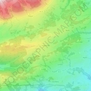
Name: Knottenried topographic map, elevation, terrain.
Average elevation: 948 m
Minimum elevation: 766 m
Maximum elevation: 1,235 m
Other topographic maps
Click on a map to view its topography, its elevation and its terrain.
Gschwender Horn
Deutschland > Bayern > Landkreis Oberallgäu > Immenstadt im Allgäu
Gschwender Horn, Immenstadt im Allgäu, Landkreis Oberallgäu, Bayern, Deutschland
Average elevation: 1,200 m