
Sal Rei topographic map
Interactive map
Click on the map to display elevation.
About this map
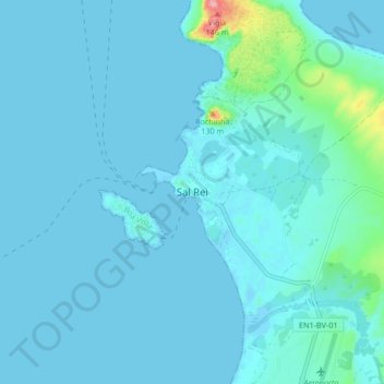
Name: Sal Rei topographic map, elevation, terrain.
Location: Sal Rei, Boa Vista, 5110, Cape Verde (16.13599 -22.95692 16.21599 -22.87692)
Average elevation: 11 m
Minimum elevation: -2 m
Maximum elevation: 136 m
Other topographic maps
Click on a map to view its topography, its elevation and its terrain.