
Ostlutter topographic map
Interactive map
Click on the map to display elevation.
About this map
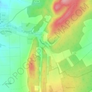
Name: Ostlutter topographic map, elevation, terrain.
Average elevation: 216 m
Minimum elevation: 150 m
Maximum elevation: 306 m
Other topographic maps
Click on a map to view its topography, its elevation and its terrain.
Lutter am Barenberge
Deutschland > Niedersachsen > Landkreis Goslar > Langelsheim > Lutter am Barenberge
Lutter am Barenberge, Langelsheim, Landkreis Goslar, Niedersachsen, 38729, Deutschland
Average elevation: 202 m