Geolocate

Mile topographic map

Click on the map to display elevation.

About this map

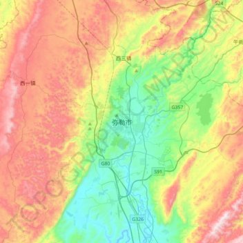
Name: Mile topographic map, elevation, terrain.

Location: Mile, Mile City, Honghe, Yunnan, China (24.25392 103.25270 24.57392 103.57270)

Average elevation: 1,748 m

Minimum elevation: 1,361 m

Maximum elevation: 2,287 m

Gear up for your next adventure:

🧭Emergency Beacons - Safety beacons for remote outdoor locations
🚶Walking Pedometers - Simple distance tracking for casual trail walkers
🧢Waterproof Hiking Hats - Keep the rain off your face while studying topographic maps
👟Heavy Duty Boot Laces - Always carry a spare for your hiking footwear
📷Camera Straps - Secure straps for carrying cameras while walking

As an Amazon Associate, this site earns from qualifying purchases at no extra cost to you.