
Make a donation
Gear up for your next adventure:
As an Amazon Associate, this site earns from qualifying purchases at no extra cost to you.
Kure Beach topographic map
Click on the map to display elevation.
Make a donation
Gear up for your next adventure:
As an Amazon Associate, this site earns from qualifying purchases at no extra cost to you.
About this map
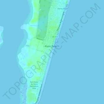
Name: Kure Beach topographic map, elevation, terrain.
Average elevation: 1 m
Minimum elevation: -2 m
Maximum elevation: 10 m
Make a donation
Gear up for your next adventure:
As an Amazon Associate, this site earns from qualifying purchases at no extra cost to you.
Other topographic maps
Click on a map to view its topography, its elevation and its terrain.
Wilmington Beach
United States > North Carolina > New Hanover County > Carolina Beach
Average elevation: 2 m
Parmele Isles
United States > North Carolina > New Hanover County > Wrightsville Beach
Average elevation: 1 m
Make a donation
Gear up for your next adventure:
As an Amazon Associate, this site earns from qualifying purchases at no extra cost to you.
Long Leaf Acres
United States > North Carolina > New Hanover County > Wilmington
Average elevation: 11 m
Make a donation
Gear up for your next adventure:
As an Amazon Associate, this site earns from qualifying purchases at no extra cost to you.
Bradley Creek Point
United States > North Carolina > New Hanover County > Wilmington
Average elevation: 3 m
Make a donation
Gear up for your next adventure:
As an Amazon Associate, this site earns from qualifying purchases at no extra cost to you.
Ogden Park
United States > North Carolina > New Hanover County > Wilmington > Ogden
Average elevation: 13 m
Wilmington Beach
United States > North Carolina > New Hanover County > Carolina Beach
Average elevation: 2 m
College Acres
United States > North Carolina > New Hanover County > Wilmington
Average elevation: 11 m
Make a donation
Gear up for your next adventure:
As an Amazon Associate, this site earns from qualifying purchases at no extra cost to you.
Hanby Beach
United States > North Carolina > New Hanover County > Kure Beach > Hanby Beach
Average elevation: 1 m
Make a donation
Gear up for your next adventure:
As an Amazon Associate, this site earns from qualifying purchases at no extra cost to you.