Geolocate

Sarah topographic map

Click on the map to display elevation.

About this map

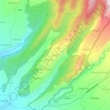
Name: Sarah topographic map, elevation, terrain.

Location: Sarah, Dharamshala, Kangra, Himachal Pradesh, 176209, India (32.15865 76.27365 32.19865 76.31365)

Average elevation: 900 m

Minimum elevation: 739 m

Maximum elevation: 1,175 m

Other topographic maps

Click on a map to view its topography, its elevation and its terrain.

Balh

India > Himachal Pradesh > Dharamshala > Dharamshala

Average elevation: 1,906 m

Kareri

India > Himachal Pradesh > Dharamshala

Average elevation: 1,849 m

Gear up for your next adventure:

🥾Trekking Poles - Poles to improve stability on uneven terrain
🧭Orienteering Compasses - Accurate compasses for map-based navigation
👖Hiking Trousers - Durable trousers designed for rough terrain
🎿Telescopic Trekking Poles - Reduces knee strain on steep topographic descents
🧼Camping Hygiene Kits - Compact hygiene essentials for outdoor stays

As an Amazon Associate, this site earns from qualifying purchases at no extra cost to you.