Geolocate

Cross topographic map

Click on the map to display elevation.

About this map

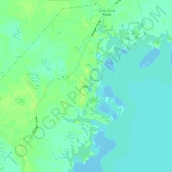
Name: Cross topographic map, elevation, terrain.

Location: Cross, Berkeley County, South Carolina, 29436, United States (33.30739 -80.16842 33.34739 -80.12842)

Average elevation: 25 m

Minimum elevation: 19 m

Maximum elevation: 32 m

Other topographic maps

Click on a map to view its topography, its elevation and its terrain.

Ladson

United States > South Carolina > Berkeley County

Average elevation: 14 m

Ladson

United States > South Carolina > Berkeley County

Average elevation: 14 m

Gear up for your next adventure:

👕Technical Hiking Tees - Moisture-management for high-exertion climbs
🛰️Handheld GPS Devices - Reliable GPS units for hiking and outdoor navigation
🌄Outdoor Binoculars - Compact binoculars for landscape observation
🌦️Portable Weather Meters - Handheld tools for monitoring weather conditions
🔦LED Camping Lanterns - Illumination for reading maps inside your tent at night

As an Amazon Associate, this site earns from qualifying purchases at no extra cost to you.