
Mesnil-en-Ouche topographic map
Interactive map
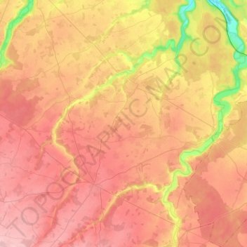
Click on the map to display elevation.
About this map
Name: Mesnil-en-Ouche topographic map, elevation, terrain.
Average elevation: 172 m
Minimum elevation: 89 m
Maximum elevation: 222 m
Other topographic maps
Click on a map to view its topography, its elevation and its terrain.
Verneuil-sur-Avre
France > Normandie > Eure > Verneuil d'Avre et d'Iton
Verneuil-sur-Avre, Verneuil d'Avre et d'Iton, Bernay, Eure, Normandie, France métropolitaine, 27130, France
Average elevation: 173 m
Pont-Audemer
France > Normandie > Eure > Pont-Audemer
Pont-Audemer, Bernay, Eure, Normandie, France métropolitaine, 27500, France
Average elevation: 77 m
Saint-Symphorien
Saint-Symphorien, Bernay, Eure, Normandie, France métropolitaine, 27500, France
Average elevation: 123 m
Les Barils
Les Barils, Bernay, Eure, Normandie, France métropolitaine, 27130, France
Average elevation: 200 m