
Coleraine topographic map
Interactive map
Click on the map to display elevation.
About this map
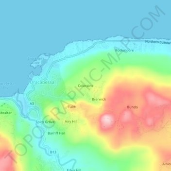
Name: Coleraine topographic map, elevation, terrain.
Location: Coleraine, Oracabessa, Saint Mary, Middlesex County, Jamaica (18.38403 -76.95584 18.42403 -76.91584)
Average elevation: 72 m
Minimum elevation: 0 m
Maximum elevation: 253 m
Other topographic maps
Click on a map to view its topography, its elevation and its terrain.
Faith
Jamaica > Saint Mary > Oracabessa
Faith, Oracabessa, Saint Mary, Middlesex County, Jamaica
Average elevation: 84 m